A Hypothetical US Partition
I was invited to write something for the front page about
my view that the American West could become
different enough from the rest of the country that
an eventual partition is possible.
Some preliminaries:
-
Yes, I know that it sounds like a lunatic fringe thing.
You don't need to harp on that.
-
When I talk about the West, I mean the 11 contiguous states
from the Rockies to the Pacific.
Alaska and Hawaii really are special cases.
-
I'm taking a long(ish) view:
it could become a subject not treated as completely crazy in 20 years,
and could happen in 30-45.
If you are mapping to the Civil War, think 1830 not 1860.
-
With tongue only partially in cheek,
it's my retirement hobby.
It's at least a book-sized project.
This is a really incomplete, condensed version of the arguments.
-
There are maps, lots of maps.
All of them make a division between east and west
that correspond roughly to the Great Plains.
My starting point is a belief that looking back from the middle of this century,
the important questions will be
"Did we keep the lights on?" and
"Did we avoid completely baking the planet while doing so?"
If the answer to the first question is no
then we're all well and truly screwed.
If the answer to the second question is no,
and the climate pessimists are right about where the positive feedback loops lead,
we're also screwed,
it may just take a little longer for things to wind up.
As a consequence
my working assumptions are that both answers are yes.
Given those,
the power grid is going to be under steadily increasing pressures:
larger population,
electrification of transportation, and
getting rid of fossil fuels.
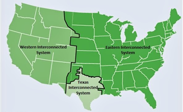
The US doesn't have one power grid,
it has three largely independent power grids:
the Eastern, Western, and Texas Interconnects,
shown in the first map.
Each of those three grids will need to provide its own solution
to the problem.
To keep this post from getting any longer
I'm going to ignore Texas and
just talk about the eastern and western grids.
The dividing line between the Western Interconnect and the others
comes close to following the center line of the Great Plains.
The states in the eastern and western grids
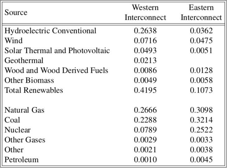
currently have very different mixes of sources for their electricity.
The fractions for different types of generation for 2017
are summarized in the first table.
There are two things to take away from this.
The West already generates almost 42% of its electricity from renewable sources
and only a small part from nuclear.
The East gets much less from renewables,
and much more from nuclear.
Most of the nuclear plants are 40 years or more old.
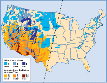
The West has large undeveloped renewable resources.
The next map shows areas with
large-scale wind and solar power resources
based on data from the National Renewable Energy Laboratory.
In addition,
there are significant
(relative to the size of demand)
unexploited hydropower resources,
both traditional and run-of-river.
Making renewable resources the source for
a stable power supply depends on having both
resource diversity and geographic diversity.
The West has those;
the East does not.
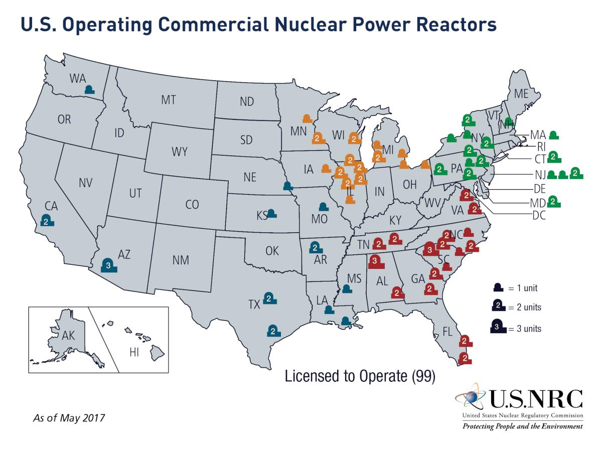
The next map shows the location of licensed nuclear power reactors.
The owners of the two reactors in California have announced
they will retire those in the early 2020s
rather than invest $4B or more to upgrade the cooling system
to meet California's new ocean thermal pollution standard.
If it were put to a popular vote in the State of Washington,
the reactor operated by the federal government's Bonneville Power Administration
would be shut down in a heartbeat.
The lack of nuclear power in the West is in part
due to the West's bad overall experience with things nuclear
and the federal government.
Examples include the long-delayed clean up of
the Hanford Nuclear Reservation in Washington,
and the entire political process that located the sole spent fuel repository in Nevada.
The initial DOE plan called for
a small repository in the West for the small number of reactors there and
a much larger repository in the East close to the larger reactor fleet.
Congress spent a few years eliminating possibilities
for political rather than technical reasons,
culminating in a 1987 bill that eliminated all candidates but Yucca Mountain,
referred to as the "screw Nevada bill" by both opponents and supporters.
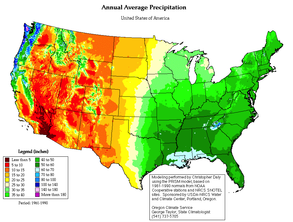
Water has always been a critical resource in the West.
Mark Twain famously described it as,
"Whiskey is for drinking; water is for fighting over."
The next map shows why:
most of the West doesn't get enough annual precipitation
to support reliable dryland farming;
most of the areas that do
(green and blue)
are mountains where the precipitation comes as snow.
In order to use it for agriculture –
and more importantly, for cooling thermal power plants –
requires storage and managed release.
Lack of available water for cooling has become
a restriction for building new thermal power plants
in the West.
When Blue Castle Holdings started looking for a site
for a potential new nuclear power plant
to sell electricity into Southern California,
eastern Utah was the closest place where they could find
available water rights.
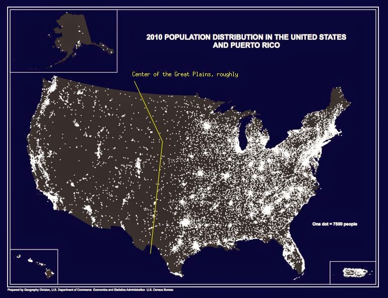
Another important consideration for the power grid is
the pattern of population in the area served.
This Census Bureau population-dot map illustrates how that pattern is different
on the two sides of the Great Plains.
In the East, there's
a town every few miles in any direction and
a larger city every hundred miles or so.
The countryside is well-populated.
The West is a small number of widely-separated major metro areas with
a enormous amount of empty in between.
There are a number of reasons for the pattern in the West.
Agriculture had to follow the few rivers.
Mountains limit the number of places suitable for cities.
The federal government owns 40% of the land and generally forbids development.
This population pattern means that
the layout of a bulk transmission system for shuttling
power from different renewable sources
can be simple.
That's the broad outline of my electricity story:
one region pursuing a low-carbon supply through a grid based on renewables and
another region that will be pushed eventually into adopting nuclear on fairly panicky terms.
There are other ways that the two regions differ
that suggest
(at least to me)
a growing separation about how to pursue those visions.
Building a power grid based on renewables in the West
bangs up against a land-ownership problem.
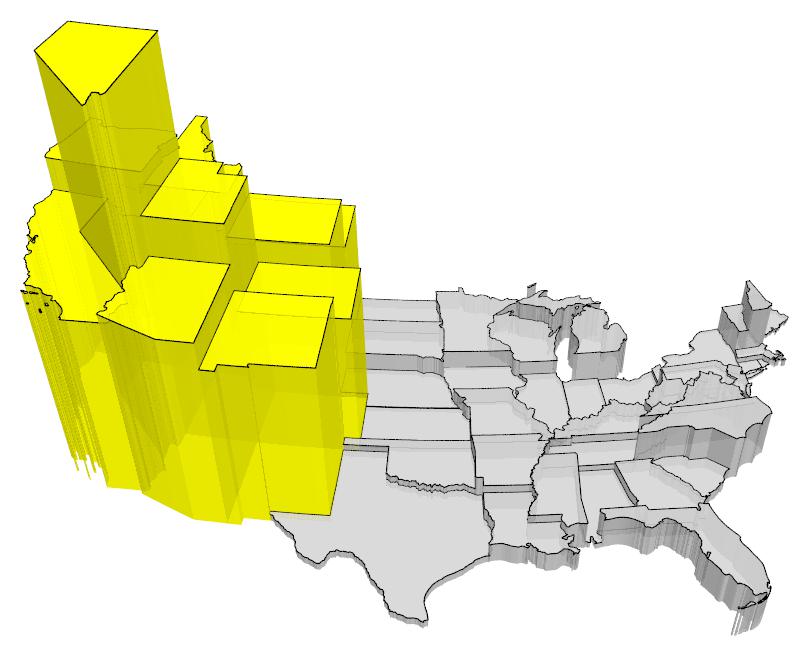
Federal land ownership is concentrated very heavily in the West.
The prism map with the 11 western states in yellow
demonstrates this clearly:
the volume of each prism reflects the amount of federally-owned land in that state.
The land ownership –
and immunity from state or local taxation, regulation, or eminent domain –
implies considerable control over where and whether
the necessary transmission links will be built.
It also puts a considerable amount of the scarce water resources and
hydroelectric generation under control of the federal government.
The politicians representing regional interests and
the federal government will increasingly
butt heads over these issues in the future.
I'm not talking about the kind of thing the Bundy fiasco was about.
These will be much larger,
like inter- and intra-state power dispatch rules and interstate utility corridors.
To quote my friend the archaeologist,
the suburbs in all western metro areas are more like each other
than they are like anything east of the Great Plains.
The 2010 census finally made it possible
to calculate population densities based on areas that have been built-out,
excluding things like the vast empty federal land holdings in the West
that were incorporated into the metropolitan area definitions
based solely on county boundaries.
Looking at metro areas of a million people or more,
and basing density on the areas actually built-out,
the West is more than 50% denser than any of the other three regions
(last column of the table).
Urban cores in the Northeast are denser,
but the US is dominated by its suburban areas and
western suburbs are a lot denser than anywhere else.
Most of the large metro areas in the West are building light rail systems.
More accurately,
when you look at the revenue sources,
the suburbs in those western metro areas
are voluntarily financing light rail systems.
I believe there are also some distinct political differences between East and West that
are already having an influence.
This past year,
Supreme Court Justice Kagan said, "The answer to partisan gerrymandering is the courts."
In the West that's simply not true:
the answer is independent redistricting commissions installed by ballot initiative.
Arizona, California, and Idaho already have such commissions
(Washington's current redistricting commission was approved by a referendum from the legislature).
This year, Colorado and Utah will vote on such commissions.
In Utah,
the proposal is currently polling a bit over 2:1 in favor.
Utah's case is a little peculiar;
the commission there will be advisory because
the voters can't change the constitution by initiative.
Still,
a 2:1 outcome in favor of independent redistricting
is a hell of a warning to the legislature.
Another aspect of the voting rights issue is practices that make voting more difficult:
for example, polling place intimidation and closing down polling stations.
The West is taking its own path towards fixing those using vote-by-mail.
Colorado, Oregon, and Washington are vote-by-mail states;
>90% of all votes cast in those states in 2016 were cast by mail.
Arizona, California, and Montana have permanent no-excuse absentee ballots.
In 2016 ~70% of all votes cast in Arizona were cast by mail.
In California ~60% were cast by mail.
In Montana ~50%.
Well over half of all ballots cast in the West in that election were cast by mail.
Vote-by-mail is very popular across all of western Democrats, Republicans, and unaffiliated voters.
I've mentioned the Great Plains multiple times.
The GP are an area 300-600 miles wide
spread over ten states extending from Canada to Mexico.
In the county-level map of those states
the GP are shown in white.
If the map is redrawn as a cartogram,
where the size of each county reflects its population,
the GP largely disappear.
Their population peaked in the 1930 census and has been declining ever since.
In many areas,
the population decline has reached the point of positive feedback:
there are too few people to support services
such as doctors and dentists;
as the availability of services decline
more people decide to relocate elsewhere.
Agriculture on the GP has always been somewhat marginal.
Only about one third has ever been plowed,
another third has been grazed,
and the final third is unsuitable for either.
Climate things will make things worse.
Much as I love all sorts of the varying ecologies that make up the GP,
I am more and more convinced that the Poppers' Buffalo Commons thoughts are correct.
A 500-mile-wide essentially empty frontier between East and West
will make some of the issues surrounding a partition simpler.